

Took a 6.3 mile, 1535 ft elevation gain hike to St. Mary’s Falls near Colorado Springs, Colorado with a group of people. Here’s some of the photos. View Photo Album
Category: Hiking
Posts on recent hiking trips, often with trail info & maps, and photos taken on the trip.
2014-01-11 South Valley Park Hike Photo Album
Took a 2 mile hike in South Valley Park with my camera at the end of a breezy but warm winter day. Some of my favorite shots in a long while resulted. Here’s some of the best. View Photo Album
Staunton State Park Exploration

I recently drove up to the new Staunton State Park just past Conifer, Colorado. It’s an easy, fairly short drive from Denver, very close to where I used to live in Pine Junction, Colorado. As you can see from this Staunton State Park trail map there are a bunch of routes to chose from whether you prefer to hike, bike or horseback ride. The day started a little brisk with fog and mist in the mountain river valleys, but turned out quite warm considering it is November in Colorado.
Having never been in the park I chose to keep it simple and take the main Staunton Ranch trail through the heart of the park. I would then take a little balloon loop hiking a short way up the Marmot Passage trail close to the top of a ridge to the west, then head back along and down the ridge on Scout Line trail until it rejoined the Staunton Ranch trail I came in on. Continue reading Staunton State Park Exploration
< 3 weeks, > 10 pounds lost, & new hiking pack
Kind of happy this evening for two reasons.
First, I hit another landmark on my goal to lose the gut and get to a healthy weight again. I’ve been using the website www.MyFItnessPal.com and their free Android App to watch what I eat and have committed myself to regular exercise (currently 30 minutes a day, 6 days a week). I have been using the site, and keeping within these food and fitness goals now for 18 days, (just under 3 weeks,) and have just crossed the 10 pound point, having last 11 pounds as of today’s weigh-in. A dynamic “ticker” showing my current weight loss and progress towards my goal should appear below.

Created by MyFitnessPal – Free Calorie Counter

Second, I got my new dedicated hiking backpack from Amazon today. It is a Osprey Kestrel 32. Awesome pack. I also got a Osprey 2 liter hydration reservoir, so now I won’t have to take my pack off all the time to get a drink. I’m hoping to try it out for the first time tomorrow. Got to get it all loaded up and ready to go tonight.
I have a number of photo / hiking sessions to report that I need to process and get archived & uploaded. Hopefully will be posting those soon, but for now I would rather go hike (and lose some more weight). So until then…
Waterton Canyon Try Out
I did a little over 4 mile “out and back” hike up Waterton Canyon today with my sister. I’ld never been up that way before. After this hike, while I’m curious enough to go back and do the full 8 mile out and back to the first major dam, it definitely is not my top choice in fun hikes in the area. Part of my lack of enthusiasm with it was that it was so hot today and there really is no shade along the route accept in a few areas. The other issue I had is that while it appears to be a great, easy mountain bike ride down a dirt road along the South Platte River, it is not the most engaging of hiking trails. That being said I only went down a short way.
Total distance: 4.5 mi, Total time: 1:41:32, Moving time: 1:21:26, Avg moving speed: 3.3 mi/h, Max speed: 6.8 mi/h, Avg moving pace: 18.1 min/mi, Fastest pace: 8.8 min/mi, Max elev: 5549 ft, Min elev: 5388 ft, Elevation gain: 797 ft.
View Waterton Canyon Hike 7/16/2012 in a larger map
That’s not to say I didn’t still enjoy it or that I won’t go back and take pictures (hopefully of big horn sheep that are said to frequent the canyon sides). I think I’ll go earlier in the day though when its cooler and do it at a much brisker pace. Between the heat and my sister’s shorter stride and painful hips, we took it slower than I normally go. But Shannon’s awesome company more than made up for the slower pace or less engaging hiking terrain. What views we saw were pretty impressive though, as you get into the rock walled canyon pretty quickly and its a nice escape from the urban sprawl where we started at the canyon’s outlet.
 We spotted several lizards (including a failed attempt at trying to herd one so we could get a good pose for the camera), swallows flying in and out of the cliffs, and butterflies. There were also a couple of fly fisherman in the river, and a lot of bicyclists, runners and hikers, as well as some school groups in the earlier parts of the trail. Needless to say it is a pretty popular place, seeing as how this was a Monday during working hours..

Kroenke Lake Hike – 6/20/12
Having driven up to Buena Vista, CO the day previously, my Dad and I got a relatively early start for our planned 8 mile hike to Kroenke Lake. The trail and destination were so gorgeous — just calling out to be explored and photographed — that we ended up doing around 9.1 miles.
Total distance: 9.1 mi, Total time: 6:30:43, Moving time: 4:18:57, Avg moving speed: 2.1 mi/h, Max speed: 5.1 mi/h, Avg moving pace: 28.4 min/mi, Max elev: 11565 ft, Min elev: 9882 ft, Elev gain: 2484 ft.
View Kroenke Lake Hike 6/20/2012 in a larger map
My Step-Mom, Leigh, set us up with a quick breakfast and packed us a protein-rich lunch while we got ready to leave. By the time we had driven up the dirt roads to the trail head it was only 8:10am or so. There were a lot of cars in the lot and the wind was gusting pretty good which had me a little worried as I had not packed a jacket or long pants. I never needed them though, as the weather the whole time was just about perfect. A family of hikers pulled up as we were leaving and passed us relatively early on the trail, and then we had things to ourselves pretty much the whole time.
The whole hike had a pretty steady elevation gain, but the first half or so was pretty mild, and the trail very easy. There were a lot of trees down in places though, which made things a little more challenging to get around, under, or over them. In one place a whole patch of forest with HUGE trees had been snapped like twigs by what was obviously a pretty intense micro-burst in the not too distant past. There were also a number of stream crossings. The first two had nice, permanent bridges, but later on there were a number of crossings that required balancing on logs or hop-scotching on rocks.
Needless to say I took a bunch of photos. I used my cell phone’s camera on the way up. Once we reached the vicinity of Kroenke Lake I broke out the SLR and started taking a lot more photos, including a few 360 photo shoots that I later digitally stitched into panoramic photos. We saw a few patches of snow near the lake, but as Dad mentioned, normally around this time of year we probably would not have been able to do the hike at all.
For high-res versions of these photos see this gallery on Picasa


The last half of the hike up was tougher, with steeper slopes, rockier trails and more tree and steam crossings. As we were arriving in the vicinity of the lake the trees became less and the views of the surrounding peaks really opened up. We saw the group that passed us at the beginning of the trail going down. Besides an apparently unoccupied tent, we had the lake all to ourselves. After taking a bunch of photos we found a big log in the meadow surrounding the lake and ate our lunch of peanut butter and bacon sandwiches… YUM! I had never had this protein/energy packed lunch. Obviously not the healthiest repast, but perfect fuel for a strenuous hike like this.
Click the panorama thumbnails below to zoom, then scroll right to see the whole panoramic view.


We took a brief break after eating to explore and take some more photos. It would have been nice to stay longer, but as tired as we were we knew we had a long, thankfully mostly downhill trek, back to our vehicle. Once again we saw other people only once on the way back just past the half-way point where a fork in the trail heads up to Harvard Peak. This encounter was a little surprising, as we were trotting along pretty quickly, when we turned a corner to see a large, apparently unattended German-Shepard like dog wearing his own packs in a saddle-bag-like arrangement. He checked us out and carried on his way, hardly breaking his stride. His human backpacking companions followed shortly later.
Photos of me on hike courtesy of Dad


Needless to say we were pretty beat when we got back to the car. While tiring, the hike was well worth it and it was a trip I won’t soon forget. Hopefully my Dad and I can take another serious hike this season. We discussed possibly returning to the start of this trail, and taking the branch that heads up to Bear Lake in a cirque above timberline surrounded by the 14,000 ft peaks of Mt. Harvard and Mt. Columbia on one side and the Continental Divide on the other. That hike however is a 10.5 mile hike without any exploring added on, so we need to keep training.
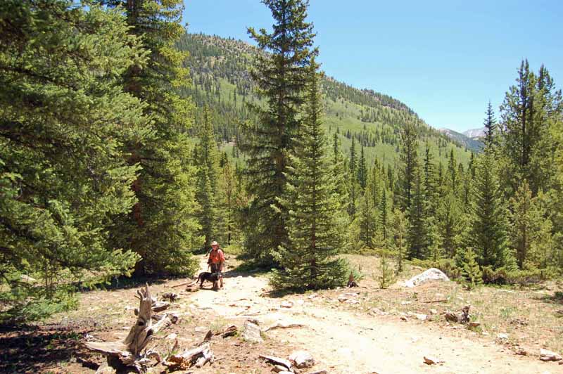
Denny Creek Trail Hike 6/19/12
Drove up to Buena Vista, CO on the morning of 6/19 to visit my Dad & Step-Mom for a couple of days. Had a great visit. Didn’t get up there until late in the morning and it was already getting pretty warm, so Dad and I decided to take a relatively short hike and take a more serious hike the following day. We decided on taking Dad’s dog Dusty with us and drove up the Cottonwood Pass road to the Denny Creek trailhead.
The trail starts out really steep, and to make matters worse, we forgot to get Dusty’s leash when we left. Luckily Dad had brought his camera bag, and we were able to use the camera bag’s strap as a crude (if short) leash. A strange feature we noticed along the trail, at least for the first mile or so, was that holes had been drilled in rocks in and along the trail. In many places there were a bunch of these rocks with holes in them a couple of inches deep, all within a few feet of each other. Only purpose I can figure is that they must be some sort of survey marks, but why so many would be needed so close to each other I haven’t a clue. Eventually these holes disappeared, but I saw something similar for a short stretch deep along the Kroenke Lake trail that we took the following day.
For higher-resolution version of these photos see this album on Picasa.


Photos taken by my Dad


Due to the heat and wrestling with the dog, we ended up getting pretty tired, and took a much shorter hike than planned. Also I wasn’t much in the mood for photo taking for some reason. Only pulled my camera out when we decided to turn back and took only a handful of photos, only a few of which I felt were decent enough to post here.
Total distance: 3.1 mi, Total time: 2:11:16, Max elevation: 10,803 ft., Min elevation: 9,871 ft., Elevation gain: 1,392 ft.View Denny Creek Trail hike 6/19/12 in a larger map
Swallow, Coyote & Columbine
Went for a hike yesterday, June 7th, at South Valley Park in Littleton along the Swallow, Coyote Song, Lyons Pass, Columbine and Cathy Johnson trails. Got a much later start than I had planned due to the previous night’s tornado and hail adventure. The park features some of the red sandstone Fountain Formations found in Roxborough State Park. They’re not as large or as numerous as those there, but still pretty cool. Being smaller the swallow nests and the birds’ aerial acrobatics are much more visible. Continue reading Swallow, Coyote & Columbine

Memorial Day Carpenter Peak Hike
I wanted to get to Roxborough State Park when it opened at 7am, since it was Memorial Day and I suspected that the park would have a lot of visitors. I didn’t quite make it though as I set off from the car at 7:26am, and it was 7:35 or so until I actually hit the trail head. Despite the fact I left later than planned, mine was one of the few cars in the lots and I initially had the place pretty much to myself. I passed only one couple on the way up and I apparently was the first to hit the peak. Only had it to myself for 5 to 10 minutes though before one person after another began to arrive. The trip down was a more or less continuous stream of hikers, which was a little annoying as you could hear people’s voices ringing out across the valley, where I usually prefer the sound of the wind, birds and such. The parking lots were completely full when I left, and there was a line of 10 to 15 cars waiting to get in the park, so all in all I’m really glad I started when I did.
I went pretty fast on the way up, taking only one “real” break. While the wild flowers were past their prime on the lower trails, the peak trail had a surprising amount. Besides two herds of deer on the drive to the trail head, the only other wildlife I saw today were birds, insects and rodents. Once I hit the peak, and on the way down I took my time and took a bunch of photos. Here’s some of the best:

Click the panorama thumbnail above to zoom then scroll right to see the whole 360 degrees.


For somewhat higher resolution version of any of these photos (except the panorama), see this photo gallery on Picasa.
GoogleMaps display of MyTracks data as gathered from my DroidX smart phone
View Carpenter Peak and Willow Creek Trails in a larger map
If you view the large version of the map above and click on the End pin either on the map or in the column to the left you will see all the details on how many miles, how high, and how long it took me. The beginning of the MyTracks data is not very accurate as I didn’t really give my phone a lot of time to narrow its position and I spent some time inside the visitor center w/ no view of the sky before I headed out on the trail. As such this is not quite as accurate as the data from my hand-held GPS, which I will add to this post later.